
Description
NOGGIN® GPR systems have been recognized by leading researchers as providing the highest quality GPR data in the world. They are also built to perform in the most demanding conditions around the globe.
Adaptable, proven GPR for any application
Available in four center frequencies and five standard configurations, NOGGIN® systems can collect data in any environment for any application. NOGGIN® spans the depths and resolutions required for subsurface investigations. Choose the combination of center frequency and configuration best suited to your application and terrain.
From simple paint marks on the ground to georeferenced depth slices, our GPR products can provide clear and concise results to prevent damage and manage underground assets.
NOGGIN®
Adaptable GPR Systems


NOGGIN® GPR systems have been recognized by leading researchers as providing the highest quality GPR data in the world. They are also built to perform in the most demanding conditions around the globe.
Adaptable, proven GPR for any application
Available in four center frequencies and five standard configurations, NOGGIN® systems can collect data in any environment for any application. NOGGIN® spans the depths and resolutions required for subsurface investigations. Choose the combination of center frequency and configuration best suited to your application and terrain.
Wi-Fi mini-reportsEmail a report of line, depth slice or map view data to your customers or colleagues.
Depth slicingCollect grids of data and view depth slices right in the field.
Map viewUsing external GPS, display a plan map view of survey path, grids, field interpretations and flags.
Field interpretationsAdd color-coded interpretations and field flags with the touch of a finger.
Optional GPSIntegrated GPS for post-processing and export to Google Earth™, CAD drawings & GIS databases.
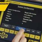
The data collection software on the DVL 500 Noggins have default settings to get to work quickly; for line surveys just set the desired depth and start collecting.
For grid collection, the GPR operator sets the grid size and line spacing. The screen prompts the user to collect each line until the grid is complete. It is easy to work around obstructions, skip lines or recollect lines if required.
Once the grid is finished (or any time after at least 3 lines have been collected), the grid data can be processed into depth slices (right in the field!).
For users involved in unusual projects, Noggins also have custom settings to collect data with extreme values:
• Depths to 200 meters (320 m in ice)
• Triggering options include Odometer, Button and Free-Run modes
• Free Run in Time or Free-Run with Speed to collect data on water, snow or ice
• Grids up to 250 x 250m in size
• Zig-zag grid collection pattern
• Step Sizes from 5 millimeters to 5 meters
Create impressive deliverables easily with EKKO_Project™ software.
After data collection is finished, transfer the data to your computer and organize, edit, process and plot your GPR data with EKKO_Project™. See your data in seconds – spend your time understanding the data, not importing and integrating ancillary information.
EKKO_Project™’s reporting capability outputs interpretations and other information into PDF, spreadsheet (csv), Google Earth™ (kmz) and CAD (dxf) files.
| NOGGIN® | ||||||
|---|---|---|---|---|---|---|

|

|

|

|
|||
| Applications (right) Terrain (below) |
Geologic mapping, geotechnical applications and deep subsurface utility mapping | SUM/SUE, Underground storage tanks (UST), Drainage systems | Archaeology, Forensics | Pavement, Bridge deck, concrete assessment | ||
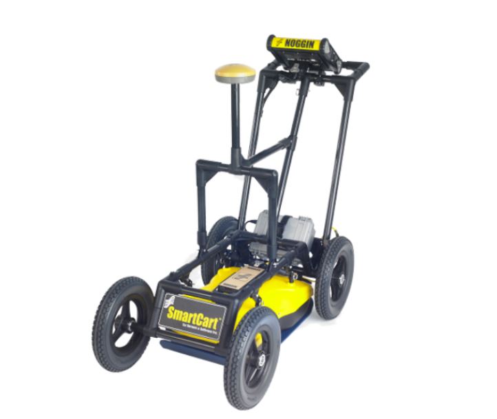
| SmartCart: Durable, 4-wheeled, folding cart |
Most terrains; flat to moderately rough |  |
 |
 |
 |
|
| SmartTow: Light, compact Tow |
Rough or difficult terrain; steep hills |  |
 |
 |
 |
|
| SmartChariot: Trailer attaches to any vehicle with a hitch |
Large, flat, open areas; roads, parks, golf courses | N/A |  |
 |
 |
|
| SmartHandle: Light, compact pull or push |
Vertical or overhead surfaces; confined spaces | N/A | N/A |  |
 |
|
| SmartSled: Towed behind any vehicle |
Large, open, rough terrains | N/A |  |
 |
 |
|

After data collection is finished, transfer the data to your computer and organize, edit, process, and plot your GPR data with EKKO_Project™ See your data in seconds – spend your time understanding the data, not importing and integrating ancillary information.